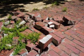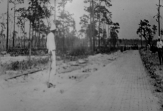
Entrance to Pershing Highway
There is some interesting history in this part of Tiger Bay State Forest located in Volusia County known as the old Pershing Highway. It was a brick road constructed in the early 1900’s and was the first highway to connect DeLand to Daytona Beach. The road was abandoned in the late 1940’s once the modern Highway 92 was completed. The road was named after the famous Word War I General John J. Pershing. It was part of the Pershing Triangle which connected Daytona, DeLand, and New Smyrna Beach.
I wrote a previous blog post about another section of this road still visible in other parts of this forest but isn’t as nice as this one in my opinion. There is no vehicle traffic is allowed on this particular section of the road. This brick road today is part of an interpretive trail where you can take a walk into the past, learn about some history of the area and see a piece of old Florida.
The “trail” or brick road here is only about a mile or so not to long of a hike. Although there are some other nice areas to explore and hike not far from here in different parts of the forest. So if you are in the area it is worth the visit for sure. Please be respectful of the history that remains, do not remove any bricks. Thank you and check out my video, photos and links below for more information.
My Video
Pershing Highway in Tiger Bay State Forest
Resources


Hello, I just recently saw this post about the Pershing Hwy. I’ve been wanting to explore this area for quite a while. I understand that part of it is drivable, but I’m interested in this walking trail. I had a few questions I was hoping you could answer:
1. Can you tell me exactly where it is? (How far west of DB, etc). It looks like it might be on the left side of 92 coming from DB, but I’m not sure. 2. Also…it’s hunting season. If I go out there now, is there a risk of getting shot?? I don’t really want to go in the heat of summer, but your blog says there is hunting allowed in the area so just want to make sure it’s safe! TIA for any information.
LikeLike
Hi you should be okay to visit this road/section of the forest without fear of hunting season that is mostly inside the main preserve. This is a short trail which is part of the old road you can walk it and take it in the past. I put a location/map on the resources link part of the post you’ll see a parking area for it right off US Hwy 92. Once you park you can walk to the kiosk and then onto the old brick road it goes for about a mile or so if that. There are other parts of the road inside the preserve as well on the other side of the Hwy but I feel this brick section is the best preserved, simply cause you aren’t allowed to drive on it.
LikeLike